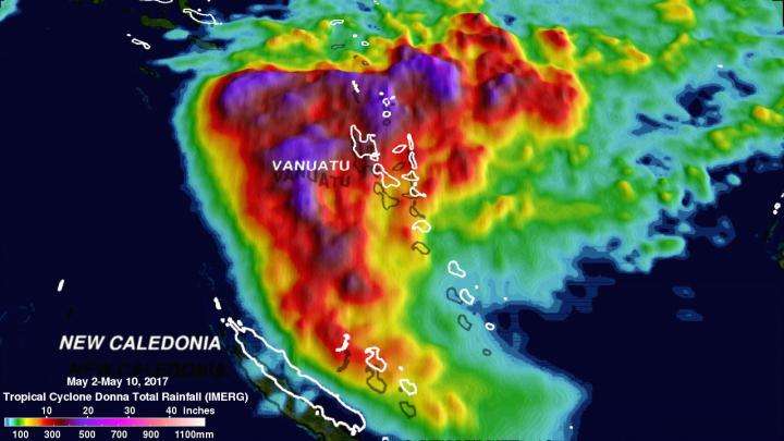
NASA analyzed powerful Tropical Cyclone Donna's extreme rainfall

Tropical Cyclone Donna was one of the most powerful out-of-season tropical cyclones ever recorded in the southern hemisphere and generated extreme amounts of rainfall along its path. NASA analyzed and mapped rainfall totals generated by the storm.
On May 10, 2017 rapidly dissipating tropical Cyclone Donna moved to the southeast of New Caledonia in the South Pacific. Up until that time, Donna spread heavy rainfall along its path from northern Vanuatu through the Loyalty Islands east of New Caledonia. Over 250 millimeters (~10 inches) of rainfall was reported in the islands of northern Vanuatu as Donna was moving through on May 5, 2017.
At NASA's Goddard Space Flight Center in Greenbelt, Maryland, a rainfall analysis was constructed using data from NASA's Integrated Multi-satellitE Retrievals for GPM (IMERG). GPM is the Global Precipitation Measurement satellite, which is co-managed by NASA and the Japan Aerospace Exploration Agency.
That data collected from the GPM core satellite in near-real time were utilized in IMERG's rainfall accumulation estimates for tropical cyclone Donna. The analysis covers tropical cyclone Donna for the period from May 2 through early May 10, 2017.
IMERG showed that tropical cyclone Donna produced some extremely high rainfall totals. It indicated that the most extreme rainfall accumulation estimates were greater than 62.4 millimeters (24.6 inches). Those extreme values were located along Donna's path through the northern islands of Vanuatu.
The tropical cyclone passed to the east of New Caledonia on the southern portion of its track so the Loyalty Islands east of New Caledonia received the heaviest rainfall in that area. By May 11, Donna had dissipated in the Southern Pacific Ocean.
The Integrated Multi-satellitE Retrievals for GPM (IMERG) is a unified U.S. algorithm that provides a multi-satellite precipitation product. IMERG is run twice in near-real time with the "early" multi-satellite product being created at about 4 hours after observation time and a "late" multi-satellite product is provided at about 12 hours after observation time. IMERG rainfall totals have been adjusted to reflect observed values in other similar extreme rainfall events.
Provided by NASA's Goddard Space Flight Center


